
The Unsolved Aviation Mystery That Captivated the World
On March 8, 2014, Malaysia Airlines Flight 370 Google Maps (MH370) vanished from radar without a trace, carrying 239 people aboard a Boeing 777 aircraft. It was en route from Kuala Lumpur to Beijing when communication with the plane ceased, triggering one of the most perplexing and tragic aviation disappearances in modern history. Despite extensive international search efforts across vast swathes of the Indian Ocean, MH370 has never been conclusively found. This has given rise to an abundance of theories—from the technical to the conspiratorial—and fueled public intrigue like no other.
Among the unconventional tools embraced by the public and independent investigators in their search for clues is Google Maps. The platform’s detailed satellite imagery has been used by amateur sleuths to scan remote ocean expanses and uninhabited regions in hopes of identifying aircraft debris or crash sites. But how viable is this approach, and has it yielded any credible results?
In this article, we examine the role of Google Maps in the search for Malaysia Airlines Flight 370, its potential for uncovering hidden clues, and whether this digital tool can offer meaningful insights into the enduring mystery.
The Disappearance of MH370: What We Know So Far
Flight Path and Final Communication
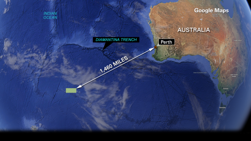
Malaysia Airlines Flight 370 took off at 12:41 AM local time and last communicated with air traffic control at 1:19 AM over the South China Sea. Shortly after, it disappeared from civilian radar screens. Military radar data later revealed the plane had veered sharply off course, turning westward over the Malay Peninsula and then heading south into the Indian Ocean.
This abrupt deviation and subsequent loss of communication were highly irregular. The aircraft’s transponder was turned off, and no distress signals were sent. The last known position, based on a final satellite “handshake,” placed the aircraft somewhere along a remote arc in the southern Indian Ocean.
The Search Effort and Its Challenges
The multinational search effort that followed was one of the largest and most expensive in aviation history. It involved oceanic scans, satellite data analysis, and international coordination between agencies. However, due to the vast and remote nature of the suspected crash site, compounded by limitations in early data interpretation, search teams failed to find the main wreckage.
While several pieces of debris confirmed to be from MH370 have washed ashore on islands along the western Indian Ocean, such as Réunion Island, these fragments have offered limited insights into the cause or location of the crash. The official investigation concluded that MH370’s disappearance was caused by a deliberate act, but could not determine who was responsible or why.
Google Maps and the Rise of Crowdsourced Sleuthing
Why Google Maps Became a Tool for MH370 Investigators
In the absence of clear answers from official channels, members of the public turned to alternative means of investigation. One of the most accessible tools at their disposal was Google Maps, particularly its satellite view and Google Earth functionality. Users can explore remote parts of the planet with high-resolution imagery, offering a potential way to spot anomalies or crash-related debris.
The premise is simple: by examining satellite images over the suspected crash zones, users might detect signs missed by official search teams. While this method lacks the precision of sonar scanning or underwater drones, it democratizes the search effort and invites global participation.
Notable Claims from Google Maps Explorers
Over the years, several individuals have claimed to have spotted MH370 or debris related to the aircraft using Google Maps. Some users on forums like Reddit and platforms like YouTube have pointed to objects resembling aircraft outlines beneath the ocean’s surface or in remote forested areas.
For example, a popular theory circulated in 2018 centered around an object seen off the coast of Cambodia that some said resembled a Boeing 777. Others have pointed to images near Mauritius or Madagascar. In 2022, a Google Maps user claimed to have discovered a submerged airplane shape in the Bay of Bengal, which reignited speculation and interest.
These sightings often go viral and attract media attention, but none have been conclusively verified. Most are later explained as coincidental shadows, natural rock formations, or outdated satellite images predating the incident.
Evaluating the Credibility of Google Maps in Solving Aviation Disasters
Limitations of Satellite Imagery for Plane Wreckage Detection
While the enthusiasm behind crowdsourced satellite searches is commendable, the limitations of using Google Maps to find Malaysia Airlines Flight 370 are significant. Most satellite images on Google Maps are not real-time and may be months or even years old. Moreover, the quality and resolution can vary significantly depending on the region and data provider.
Oceanic regions are particularly difficult to analyze due to wave patterns, depth, and cloud cover. Wreckage submerged even slightly below the surface becomes nearly impossible to detect with the human eye using standard satellite imagery.
Additionally, without metadata such as the date of the image capture or more sophisticated imaging tools (like infrared or multispectral sensors), any analysis remains speculative at best.
Official vs Amateur Investigations: Can They Coexist?
Despite the shortcomings, the global community’s interest in MH370 and the use of open-source tools like Google Maps reflect a new era of citizen involvement in large-scale investigations. Official agencies operate under procedural constraints, while the public can think creatively and pursue unconventional theories.
That said, the need for scientific rigor and data verification remains paramount. Crowdsourced findings must be cross-examined with known data points, aviation knowledge, and on-the-ground or undersea searches to ensure credibility.
The Role of Technology and AI in Future Search Missions
Combining Google Maps with Advanced Analytics
Though Google Maps alone may not be sufficient to locate MH370, it can become a component in a more comprehensive digital strategy. When paired with AI-powered image recognition, satellite data can be sifted for patterns or anomalies far more efficiently than human observers scrolling through miles of imagery.
Machine learning algorithms are increasingly being used to analyze oceanographic data, map debris fields, and even simulate potential crash trajectories based on weather, fuel, and mechanical data. If these technologies were integrated with platforms like Google Maps, they could create a publicly accessible yet scientifically reliable way to track potential findings.
Encouraging Responsible and Ethical Sleuthing
Another key consideration is the emotional and ethical weight of engaging with such tragedies. Families of MH370 victims have endured years of uncertainty and trauma. Misinformation or sensationalized claims—especially those unsubstantiated and widely shared online—can compound their grief.
Therefore, while technological curiosity and participation are welcome, responsible behavior and sensitivity to those directly affected should remain a guiding principle for all involved.
Ongoing Efforts and Renewed Hope
Ocean Infinity’s Renewed Search in 2025
As of 2025, there is renewed hope that the mystery of MH370 may finally be resolved. The marine robotics company Ocean Infinity has proposed a new search mission using state-of-the-art autonomous underwater vehicles (AUVs). Unlike previous missions, this one is performance-based—only to be compensated if MH370 is found.
This adds a powerful financial incentive and reflects growing confidence that technology has matured enough to succeed where previous missions have failed.
Could Google Maps Still Play a Role?
While Google Maps alone may not pinpoint the wreckage of MH370, its accessibility makes it a powerful auxiliary tool. It can be used by researchers to visualize search areas, overlay ocean current patterns, or compare debris discovery locations.
In essence, Google Maps serves not as the key to solving the mystery, but as a supporting character in a much larger ensemble—one that includes satellites, AI, sonar, and, importantly, human persistence.
Conclusion
More than a decade has passed since Malaysia Airlines Flight 370 vanished, and the world continues to seek answers. In a time where technology permeates every facet of our lives, tools like Google Maps give ordinary citizens the chance to participate in this search. While the platform has yet to provide conclusive breakthroughs, its impact on public engagement and awareness cannot be understated.
As official search efforts resume with renewed vigor, and as AI and satellite tech evolve, the synergy of crowdsourced interest and professional expertise could finally bring closure to one of aviation’s greatest mysteries. Until then, the case of MH370 remains a haunting symbol of loss—and a reminder of both the power and limits of modern technology in the face of the unknown.
Read more: TNT Sports Schedule 2025: Full Listings of Live Matches, Events, and Broadcast Times